Montana Map
|
 |
 |
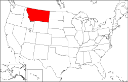
Where Is Montana?
The State of Montana, colorized in red on this map, is bounded by the Canadian Province of Alberta on the north and by Wyoming on the south. Montana is bordered by North Dakota on the east and by Idaho on the west. It is bounded by the Canadian Province of Saskatchewan on the northeast, by the State of South Dakota on the southeast, and by the Canadian Province of British Columbia on the northwest.
Montana Maps
Montana is the 4th largest state in the United States, covering a land area of 145,552 square miles (376,980 square kilometers). There are 56 counties in the State of Montana. This Montana map site features road maps, topographical maps, and relief maps of Montana. The detailed, scrollable road map displays Montana counties, cities, and towns as well as Interstate, U.S., and Montana state highways. The pannable, scalable Montana street map can be zoomed in to show local streets and detailed imagery.
Montana Highway Map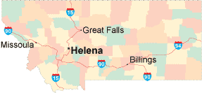 Click on the highway map thumbnail
to view a scalable Montana road map. |
MT Topo Map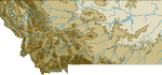 Click map to enlarge.
|
MT Relief Map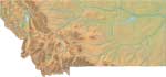 Click map to enlarge.
|
The detailed Montana map and the regional Montana map display cities, roads, rivers, and lakes as well as terrain features. The detailed map shows only the State of Montana, while the regional map shows Montana and the surrounding region.
Montana Infrastructure > Montana Airports
In 2005, the population of Montana was estimated at 934,737, which is about 6.4 people per square mile. In 2010, Montana's population rose to 989,415 people. More recently, in the 2020 census, the Montana population was 1,084,225. The state's Interstate Highways include I-15, I-90, and I-94.
Montana Topography and Attractions
Montana is named after the Spanish word "montana", which means "mountain" or "mountainous region". Western Montana features mountain ranges that are collectively known as the Rockies, while eastern Montana is part of the Great Plains. The state is drained by the Missouri and Yellowstone Rivers. Glacier National Parks and Custer Battlefield National Monument draw many visitors to Montana's frontier each year. For comprehensive travel and tourism information about Montana, visit the official Montana tourism site and Montana Atlas.
Other Maps of Montana
This online Montana reference map shows major cities, roads, railroads, and physical features in Montana.Several map publishing companies offer printed maps of Montana. For example, Omni Resources offers several maps of Montana that feature points of interest, airports, and parks, as well as selected local attractions and insets of major Montana cities.
All rights reserved.
Certain maps hereon are © Map Resources or Digital Wisdom.
To facilitate browsing, certain external links will open in new windows.
Montana-Map.org Editor, State Maps, PO Box 828, Barnegat, NJ 08005.